
Currently Empty: $0.00


9.3 The Rectangular Survey System
The Rectangular Survey System
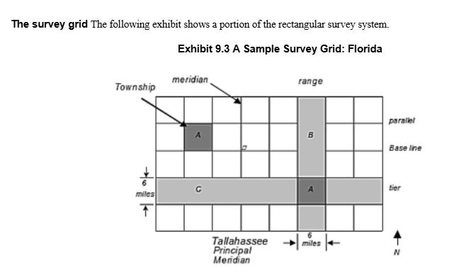
The rectangular survey system (government survey method) was developed to standardize property descriptions, especially for large tracts of land in the Midwest and West. It uses latitude (east-west) and longitude (north-south) lines to create uniform grids of squares (townships).
Key elements:
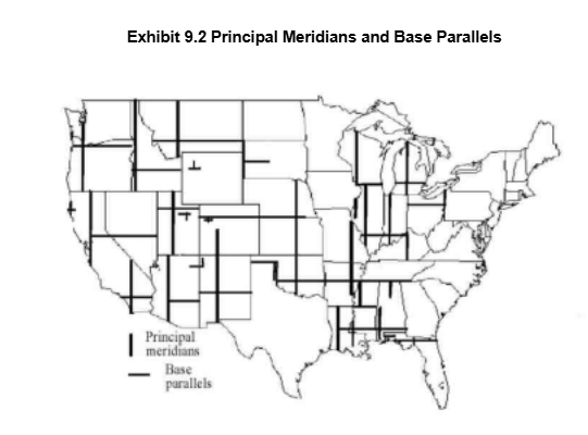
- Principal meridian: Main north-south line for survey reference (see map above).
- Base parallel (base line): Main east-west reference line.
- Range: North-south strip between meridians (6 miles wide).
- Tier: East-west strip between parallels (6 miles wide).
- Township: 6-mile by 6-mile square formed by intersecting ranges and tiers (36 square miles).
Sections of a Township: Each township is divided into 36 sections, each 1 mile by 1 mile (1 square mile, 640 acres). Sections are numbered in a unique order, starting at the northeast corner.
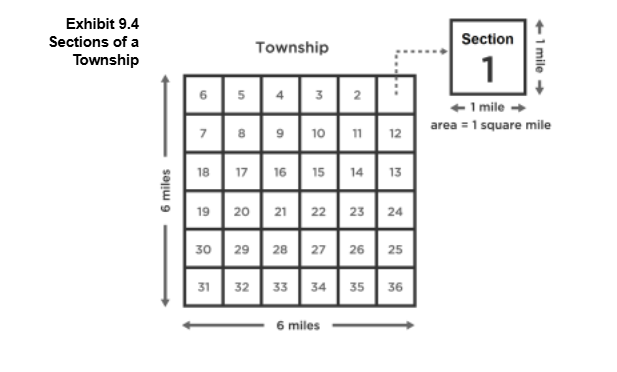
- Sections can be subdivided into halves, quarters, etc. (e.g., SW 1/4 of a section = 160 acres).
- To convert section fractions to acres: Multiply the denominators and divide 640 by that number (e.g., E 1/2 of SW 1/4 of SW 1/4 = 640 / (2×4×4) = 20 acres).
- Best for describing square/rectangular properties; irregular shapes may require metes and bounds or plat method.
Check-In Questions
- How many acres are in one section of a township?
Show Answer
Correct Answer: 640 acres
Each section is one square mile, or 640 acres. - What is the formula to find the acreage of a section fraction?
Show Answer
Correct Answer: Divide 640 by the product of the denominators
Example: E 1/2 of SW 1/4 of SW 1/4 = 640 / (2×4×4) = 20 acres.
Recorded Plat Method (Lot & Block System)
The recorded plat method is used for properties in subdivisions. Land is surveyed and divided into lots (and sometimes blocks), then mapped on a subdivision plat. The plat map is recorded in the county, and lot/block numbers become the legal description.
- Common for residential, commercial, and industrial subdivisions.
- Plat must comply with local standards and be officially recorded.
- The full legal description includes lot, block, subdivision name, section, township, county, and state.
Example:
“Lot 7, Block 8 of the Panther Ridge, the Forest Subdivision of the SE 1/4 of Section 35, Township T28S, R19E of the Tallahassee Principal Meridian in Manatee County, Florida.”
Check-In Questions
- What does the recorded plat method use to describe property?
Show Answer
Correct Answer: Lot and block numbers from a subdivision plat map
The plat method is also called the lot and block system. - What must a recorded plat legal description include?
Show Answer
Correct Answer: Lot, block, subdivision, section, township, county, and state
The full legal description is comprehensive and precise.