
Currently Empty: $0.00


9.2 Metes and Bounds
Metes and Bounds
A metes and bounds description defines the boundaries of a parcel using reference points, distances, and angles. It always starts at a point of beginning (POB) and ends by returning to that same point, enclosing the area.
- Metes: Distance and direction measurements.
- Bounds: Fixed reference points (monuments or landmarks), which can be natural (trees, rivers, rocks) or artificial (stakes, markers).
- Begins by identifying the city, county, and state, then the POB, followed by the perimeter in sequence.
- Must return to the POB for validity.
- Often used in older states and sometimes within the rectangular survey system.
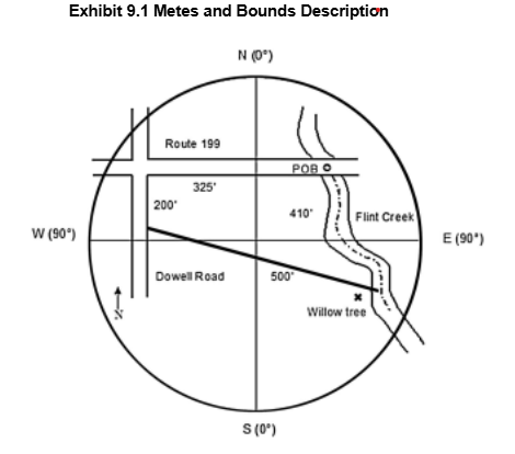
Example (from Exhibit 9.1):
“A parcel of land located in Bucks County, Pennsylvania, having the following description: commencing at the intersection of the south line of Route 199 and the middle of Flint Creek, thence southeasterly along the center thread of Flint Creek 410 feet, more or less, to the willow tree landmark, thence north 65 degrees west 500 feet, more or less to the east line of Dowell Road, thence north 2 degrees east 200 feet, more or less, along the east line of Dowell Road to the south line of Route 199, thence north 90 degrees east 325 feet, more or less, along the south line of Route 199 to the point of beginning.”
Check-In Questions
- What is required for a metes and bounds description to be valid?
Show Answer
Correct Answer: It must start and end at the point of beginning (POB)
The description must enclose the area by returning to the POB. - What do “metes” and “bounds” refer to?
Show Answer
Correct Answer: Metes: distance and direction; Bounds: monuments and landmarks
“Metes” are measurements; “bounds” are reference points.